EROSION/LANDSLIP REMEDIATION – WARRENBAYNE
When: 2022
Client: Benalla Rural City Council
Overview: Due to recent storm damage, existing gully erosion started to impact the road and cause damage to roadside drainage. BPS were engaged by the Benalla Rural City Council to facilitate an engineering feature survey for the purpose of designing site rehabilitation.

Works include:
Baddaginnie Creek runs alongside Davies Road and sustained gully erosion, which had been occurring for some time. With recent rains, the gully erosion worsened and impact the road, causing the roadside drain on the east side of the roadway to erode.
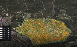
The surrounding area above and below the road and creek were imaged by BPS engaged specialist AUAV Aerial Drone and UAV Services for LiDAR data at 10m spacings to map an active slip along Davies Road through dense tree cover. Local control and engineering feature survey and design was completed by BPS. The output was highly accurate topographic 3D modelling of the complex erosion site.
Browns Project Solutions
Contact Us
Quick Links


Browns Project Solutions acknowledges and pays respect to the past, present and future Traditional Custodians and Elders of this nation and the continuation of cultural, spiritual and educational practices of Aboriginal and Torres Strait Islander peoples.
Browns Project Solutions are also committed to advancing diversity and inclusivity throughout all aspects of our workplace, ensuring equal opportunity and respect for all.
